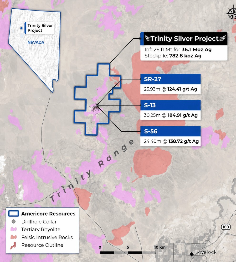
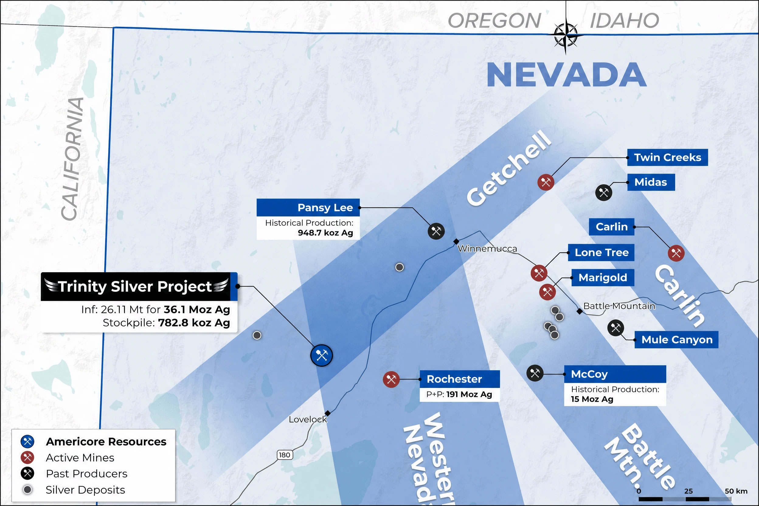
Trinity Silver

Americore Resources • Pershing County, Nevada

Trinity Silver Project

A 22,700-acre district-scale silver project in Nevada with a historical resource of 36.1 million ounces silver equivalent, a 782,800-ounce silver stockpile ready for processing, and a clear path to resource expansion drilling.

36.1 Moz
Historical Silver Eq. Resource
782.8 koz
Silver Stockpile (1989)
22,700 ac
District Land Package

District-Scale Land Position

Located in Pershing County, Nevada, approximately 17 miles north-northwest of Lovelock. Accessible by maintained roads from Interstate 80, with proximity to the Union Pacific rail corridor, grid power, and established water infrastructure.

Americore holds options on 100% of two fee simple sections (surface and mineral rights) and 83 unpatented lode mining claims, plus a lease position spanning 21 sections. An additional 73 staked claims bring the total land package to approximately 22,700 acres.

Trinity Silver Project Property Map
Trinity Silver Project Regional Context

Nevada’s Silver Corridor

Trinity sits in one of Nevada’s most productive silver corridors, in the same county as Coeur Mining’s Rochester mine — which produced 15.4 million ounces of silver in 2025 following a major expansion. Results at adjacent properties are not necessarily indicative of results on the Trinity property.

Rochester Mine
Coeur Mining (NYSE: CDE)
Pershing County, NV
191 Moz silver proven & probable
McCoy Deposit
Historical Production
Lander County, NV
~15 Moz silver
Pansy Lee
Past Producer
Pershing County, NV
948.7 koz silver
Trinity Silver
Americore Resources
Pershing County, NV
36.1 Moz AgEq historical • 782.8 koz stockpile

Production and resource figures for adjacent properties are sourced from public disclosures and are not indicative of results on the Trinity property.

A Former Producer, Not a Grassroots Play

Trinity is a former producer. US Borax mined silver here in the late 1980s when prices were below US$7/oz, demonstrating the presence of significant silver mineralization. That track record, plus a 353-hole drill database, gives Americore a head start most explorers don’t have.

Early 1980s
Discovery & Exploration

US Borax and Santa Fe Pacific Minerals explored the Trinity Range with extensive drilling, identifying a structurally controlled silver-lead-zinc system hosted in rhyolite.

1987 – 1988
Mine Development & Production

US Borax and a joint venture partner operated an open-pit heap leach mine, mining 1,085,790 tons at an average grade of 6.32 oz/t silver and recovering approximately 5 million ounces of silver. Operations were suspended due to low silver prices — a result of market conditions at the time, not a reflection of deposit geology.

1989
Stockpile Left on Surface

Processing terminated. A stockpile of 428,634 tons containing an estimated 782,769 ounces of silver was left on surface. It remains on the property as a potential future processing consideration, subject to additional metallurgical study and economic analysis.

2006 – 2012
Modern Exploration & NI 43-101

AuEx Ventures conducted modern exploration including a 20-hole RC drill program. In 2012, SRK Consulting prepared an NI 43-101 inferred resource estimate of 36.1 Moz silver equivalent.

2010
Reclamation Complete

Newmont fulfilled all closure obligations. Nevada released the reclamation bond — no legacy environmental liabilities remain.

2025 – Present
Americore Acquires & Advances

Americore assembled the 22,700-acre land package, completed Phase 1 data compilation with AI-assisted geological analysis, and is now permitting a Phase 2 drill program.

Trinity Silver Project Site Overview

Predictable Geology, Untested Boundaries

Silver mineralization at Trinity is controlled by a network of deep fault zones that channelled metal-bearing fluids through porous volcanic rock (rhyolite), concentrating silver into predictable, drillable corridors. The system’s alteration footprint extends 1.6 miles beyond the main mineralized area — far larger than the area drilled to date.

More recent studies have re-interpreted Trinity as an orogenic system — a deeper, more extensive style of deposit than originally modelled. The deposit remains open at depth and along strike, meaning drilling has not yet found the edges. SRK identified five fault corridors in the resource model, each a defined drilling target. The existing open pit sits on the strongest — the Trinity Fault zone — while peripheral zones remain underexplored.

The deposit has two layers: a shallow oxide zone where silver can be extracted cheaply through heap leaching, and a deeper sulfide zone containing silver, lead, and zinc that would require conventional milling. Two distinct mineralization styles, each with different processing considerations.

Trinity Silver Project Geology Map
Re-Interpreted Model

Now understood as an orogenic system — deeper and more extensive than the original open-pit heap leach model. Open at depth and along strike, with structurally controlled geometry interpreted to be consistent and amenable to systematic drilling.

Host Rock

Rhyolite porphyry, aphanitic rhyolite, and volcaniclastic rocks. Alteration halo extends 1.6 miles beyond the main mineralized area.

Structural Controls

Five fault corridors mapped by SRK. Geophysical entropy analysis has identified zones of structural complexity with high prospectivity beyond the current resource.

Oxide vs. Sulfide

Oxide: silver-dominant, heap-leachable, lower cost. Sulfide: polymetallic, higher value per tonne, requires flotation.

Expansion Potential

Open at depth and along strike. Drill spacing widens from 100 ft in the core zone to 350 ft at the margins — significant room to grow.

36.1 Million Ounces Silver Equivalent

Estimated by SRK Consulting (U.S.) Inc., effective December 18, 2012, in compliance with NI 43-101 standards. Based on 353 drill holes totaling 159,261 feet. All material classified as Inferred. Historical estimates are not treated as current resources by the Company.

36.1 Moz
Total Silver Eq. (Oxide + Sulfide)
26.22 Mt
Total Historical Tonnage
353
Drill Holes in Database

Oxide Silver Resource

Category Cut-off (g/t silver) Tonnes (000s) Silver Grade (g/t) Contained Silver (oz)
Inferred 17.1 5,833 38.87 7,287,000

Sulfide Silver-Lead-Zinc Resource

Category Cut-off (Silver Eq. g/t) Tonnes (000s) Silver (g/t) Lead (%) Zinc (%) Silver Eq. (g/t) Contained Silver Eq. (oz)
Inferred 27.4 17,953 36.68 0.217 0.354 50.05 28,837,000

Mineral resources are not mineral reserves and do not have demonstrated economic viability. There is no certainty that all or any part of the mineral resource will be converted into mineral reserves. Resources are stated as contained within a single potentially economic open pit using a 0.5 oz/t silver cut-off for oxide and a 0.8 oz/t silver equivalent cut-off for sulfide. Pit optimization used silver, lead, and zinc prices of US$31.08/oz, US$0.94/lb, and US$0.88/lb respectively. A 4% NSR royalty was applied. Oxide recovery of 68.6% silver; sulfide recovery of 85% for silver, lead, and zinc. Qualified Persons: J.B. Pennington, M.Sc., C.P.G. (SRK) and W.M. Martin, M.Sc., C.P.G. (JBR). Historical estimates are not treated as current resources by Americore.

1989 Mineral Stockpile

A stockpile from 1987–89 mining remains on the property, containing an estimated 782,769 ounces of silver across oxide and sulfide fractions.

Oxide Stockpile
417,022 oz silver
360,827 tonnes • 32.5–48.0 g/t silver
Sulfide Stockpile
365,747 oz silver
28,023 tonnes • 325–470 g/t silver

Broad Intervals, Strong Internal Grades

Wide, consistently mineralized intervals along the Trinity Fault zone — geometry consistent with the style typical of bulk-tonnage, open-pit deposits. Higher-grade internal zones offer upside for selective mining.

Section 10,450N
Hole SA2
112.85 m @ 55.43 g/t silver
Incl. 16.77 m @ 119.00 g/t Ag and 38.12 m @ 80.11 g/t Ag
Section 10,350N
Hole S-45
94.00 m @ 110.98 g/t silver
Widest high-grade intercept in the Trinity dataset.
Section 10,350N
Hole SR-10
77.78 m @ 104.59 g/t silver
Broad mineralized envelope along the Trinity Fault zone.
Section 10,350N
Hole S-30
57.95 m @ 97.63 g/t silver
Confirms lateral continuity along structure.
Notable Intercept
Hole SR-2
4.58 m @ 570.43 g/t silver
High-grade shoot demonstrating the system’s ability to concentrate exceptional silver values.
Section 10,450N
Hole S-13
30.25 m @ 184.91 g/t silver
Strong grade over meaningful width in the central deposit.

Mineralization Open at Depth

A longitudinal section through the pit highlights the interpretation that many of the historical holes are too shallow. Two key intercepts — both terminated at the bottom of hole — confirm the mineralized system extends well below the depth of existing drilling, representing a significant untested target.

Bottom of Hole
Hole S-133
105 ft @ 390.69 g/t Ag
280 to 385 ft — bottom of hole. Mineralization not closed off.
Bottom of Hole
Hole S-113
260 ft @ 149.69 g/t Ag
120 to 380 ft — bottom of hole.
Incl. 55 ft @ 455 g/t Ag from 265–320 ft.
Trinity Silver Project — Long Section Looking NW, Silver Grade

Long Section Looking NW — silver grade colour zonation. The circled area marks holes stopped in significant mineralization, confirming the system remains open to depth.

Core Hole Intersections — Trinity Pit Area

Core drilling within and adjacent to the historical pit confirms mineralization continuity and high-grade zones at depth.

Hole ID From (ft) To (ft) Interval (ft) Silver (g/t)
SC-1 8.5 330.0 321.5 65.86
incl 160.0 220.0 65.0 220.69
SC-2 125.0 285.0 160.0 70.26
incl 130.0 175.0 45.0 174.32
SC-3 9.0 135.0 126.0 33.48
SC-4 197.0 406.5 209.5 145.98
incl 244.0 397.0 153.0 185.94
SC-5 8.0 254.5 246.5 97.52
incl 84.0 154.0 70.0 128.26
and 205.5 229.0 23.5 162.69

SC-2 upper portion (0–125 ft) was mined out from the historical pit. True widths are estimated to be 80–95% of drilled intervals based on fault dip geometry. All results from historical drilling programs.

From Data to Drills to Definition

A three-phase plan to move Trinity from a historical resource to a modern, NI 43-101-compliant estimate with updated metallurgy and preliminary economics.

Completed

Phase 1

Data Compilation & Target Generation

353-hole drill database compiled. AI-assisted geological analysis, airborne and hyperspectral surveys completed. Phase 2 permitting initiated.

Next

Phase 2

Resource Expansion Drilling

Confirmation and infill drilling to upgrade inferred material toward indicated. Core drilling for metallurgical samples. Step-out holes to test expansion along strike and at depth.

Follow-on

Phase 3

Economic Assessment

Updated Mineral Resource Estimate (MRE). Preliminary Economic Assessment (PEA) with metallurgical results, mine design, and current pricing. Environmental baseline and development planning.

Join Our Mailing List

Sign up to receive updates on our latest news and events. Your email will never be shared or sold and you can opt out at any time.

No, I don't want to receive updates

Thank you for subscribing!

We'll send you updates on our latest news and events.

Close